29 April 2020

Foodling: DungeonMorph Dice Geomorphs --> Castle Greyhawk Sub-Level

Last night, I created a new sub-level for my version of Castle Greyhawk, using the DungeonMorph dice from Inkwell Ideas.  I was a backer of their original Kickstarter in 2011, and remain quite fond of their geos dice, and of dungeon geomorphs in general!

Here's the original geomorphs dice used for inspiration:


DungeonMorph Dice -
level arrangement by grodog


And here's the level as I rendered it:

Convection Sub-Level in Castle Greyhawk-
draft map by grodog


You'll note that I largely ignored the caverns in the eastern half of the dice image, save for general sizing and some shape inspiration.
If you're curious, full-sized versions of the images are at:
Enjoy, and stay safe amidst the covid-chaos!

Allan.

25 April 2020

The Strange Case of the Forgotten Folio Forest

Life's been very busy and distracted of late with changes in our daily homelife and work routines caused by the COVID-19 outbreak in the 'States.  Thankfully our family has remained untouched by the virus to date, but it has slowed down my sharing via the blog.  

I've managed to keep designing and writing (and editing, and drawing, and...), and hope to return to a more-regular pace soon.  In the meanwhile, I hope you enjoy this bit of Greyhawk research trivia.

==

At the topographical level, the Flanaess is filled with many strange and wondrous features, some inherently magical or the result of the expenditure of vast magical energies in aeons past---the Land of Black Ice, the sunken Isles of Woe, and the Bright Desert may, perhaps, all owe their infamy to such magics.

There are, however, additional and perhaps greater powers at play in the World of Greyhawk.  Powers that shape the course of all of The Flanaess, of Oerik, Oerth, and the multiverse itself---and beyond!  I am, of course, referring to the powers and perils of editing within the game design process! ;)


In particular, today I'm referring to a forest that is largely lost in Greyhawk's publishing history---a forest that straddles the Crystal River in central Furyondy.  "Wait!" you say, "there is no such timberland in Greyhawk!"  And in most instances of the maps of the Flanaess, you would be correct:  


The Crystal River, in central Fuyrondy -
Greyhawk Folio 1980


All subsequent versions of officially-published Greyhawk maps also omit this feature:  the 1983 Boxed Set, From the Ashes in 1992, The Marklands in 1993, Greyhawk: the Adventure Begins in 1998, the 2000 D&D Gazetteer and 2001's Living Greyhawk Gazetteer, the Furyondy Triad's Gazetteer in 2002, and the Dungeon Magazine four-part Greyhawk maps in 2005. 

However, in its large-scale continental and migrations maps, the 1980 Greyhawk Folio clearly depicts this forgotten forest:


The Continent of Oerik - Greyhawk Folio, 1980
The Continent of Oerik -
Greyhawk Folio, 1980
Human Migrations into the Flanaess - Greyhawk Folio, 1980
Human Migrations into the Flanaess -
Greyhawk Folio, 1980

I've also zoomed-in and colored the forest for clarity:


The Continent of Oerik, mangled by grodog -  Greyhawk Folio, 1980
The Continent of Oerik, mangled by grodog - 
Greyhawk Folio, 1980


Now, that does not mean that the forest is an error or oversight on the smaller maps, and neither does it mean that fandom has completely ignored the forest, either.   The forest appears on Gary Gygax's original sketch maps for the 1980 Folio Map; unfortunately I cannot share images from those maps at present, so you'll have to take my word that it appears therein. 

Anna Meyers' Greyhawk maps are the other major source that marks the forest, and not just her 576 CY maps that I linked to, but all of them:


Flanaess Full Map 576 CY (zoomed-in view) -
by Anna Meyer


You too can zoom into the above view through Anna's Flanaess Full Map 576 CY - 2020 Edition.  In addition to placing the forest, Anna christened it as the "Hindewode." 


This is my working-map for placing the forest in the Darlene maps' hex coordinates grid:
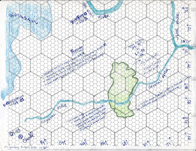

The Forgotten Forest - Map by grodog
The Forgotten Forest - sketch map by grodog
(orient sheet with large hexes flat for easier reading of notes)


I wanted to work through the hex location of the forest, estimating via the Folio maps, so I grabbed an old homemade hex sheet I'd drawn as a kid from TSR's Hexagonal Mapping Booklet (you can see some of the larger hex lines are somewhat crooked in places ;) ), pivoted it 60°, and called it good enough to sketch on.  Based on my interpretation of the forest's placement, it occupies the J4-79-ish to L4-82-ish hexes.   

You'll see in my notes that the forest, as drawn on the Folio continental map, is similar in size to the Axewood (which has a different shape as rendered in the published version of the maps), as well as comparable to the unnamed forests in the south of Veluna and west of the Gnarley---also named by Anna as Dapple Wood (Northern and Southern sections) and Iron Wood.  

In total, the forgotten forest spans about three to three-and-a-half of Darlene's 30 mile hexes, which breaks down into about 14 1/2 five-mile hexes (six per larger campaign hex) in length, and 9 five-mile hexes in width, as measuring across the longest and widest points of the forest. 

I'll write next about the fun aspects of what this missing forest means in the context of my current Greyhawk campaigns!

Allan.